Tuesday, May 29, 2012

THE BIG GRAND CANYON

Well, we made it to the Grand C.  It is truly something to see.  When we were at the Canyonlands, the Ranger who gave interpretive talks said the only place better to see than Canyonlands was the Grand Canyon.  She was right!

 When you enter the park from the east, the area is call Desert View.  The main attraction - beside the view - is the Watchtower.  It was designed by Mary Elizabeth Jane Colter in 1932 to resemble a Puebloen tower.  It sits on the edge of this part of the canyon and gives you an elevated view of the canyon below.


The inside of the tower is painted with Indian symbols and decorations


And of course, the view is something else!!


At the west end of the canyon is Hermits Rest.  How it got its name is a story longer than this post.  It was one of the first areas visitors who came to the Grand Canyon ventured out to see. 

From Hermits Rest you can look deep into the canyon and see the Colorado River continuing to work its magic along the steep cliffs.  We are several miles above the river.  There are several sets of rapids that can be seen.


If you look very closely you will see a raft working its way down river.  They have just completed navigating the rapids above.


Taking pictures of the canyon is more than your camera can handle.  I think you really need some special equipment to take in the vast vistas.


The GRAND CANYON is indeed a very special place.  America has such riches for everyone to enjoy.  God has truly blessed us.

Wednesday, May 16, 2012

Glen Canyon Dam

We spent a few days in Page, AZ to see the Glen Canyon Dam and Lake Powell.  Page is a town created by the building of the dam.  It now has about 9000 residents and a community college.

This is a picture of the dam from the down stream side.  Glen Canyon is built on the Colorado River during the early 1960.  There was much talk about the dam during the time Steve was at UC so he was interested in seeing the 'real thing'.


The dam is a hydro-electric facility with 8 generating turbines.  The bridge was built first and the dam after.  Concrete was continually poured - 24 hours a day--seven days a week - for over 3 years.


This picture was taken up stream of the dam from Lake Powell and really shows the bridge over the Colorado River.


The dam created Lake Powell second only in size to Lake Mead created by the Hoover Dam which is located down river close to the Arizona-Nevada border.


Sunday, May 13, 2012

Zion National Park

As much as Bryce Canyon is about looking down into canyons, Zion is about looking up.  Up at shear walls of rocks created by the Virgin River working its artistic hand over million of years.

While there, we took two hikes to get up close and personal with the rocks.  These pictures were taken from the Riverwalk hike.


Wednesday, May 9, 2012

Bryce Canyon National Park

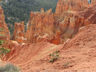
Bryce Canyon National Park is a scenic wonder.  It is amazing what the wind and rain can to to rocks over time.  The main feature of the park are rock formations called Hoodoos.  These are formations caused by a hard top layer of rock - usually dolomite or Navajo sandstone with red wyngate underneath.


The hoodoos look like tall very thin people generally with grey hair - the Navajo sandstone.  The 16 mile trip through the park is dotted with overlooks where you can look down on the strange and remarkable rocks.  Sometimes you wonder how the hoodoo remains standing.  A hoodoo does have a 'life' because when it looses it white top erosion will eventually cause it to crumble.


Wednesday, May 2, 2012

Capital Reef National Park

Yesterday we spent the day exploring Capital Reef National Park.  It is located on the way from Arches/Canyonlands NPs to Bryce Canyon NP.  It has some very interesting rock formations and some petroglyphs from the early Fremont people.


This rock formation is named 'The Capital Dome' because it resembles the Capital Dome in Washington DC.  It is also the name sake for the park.  The Reef comes from some of the early explorers who were seafaring men and when the rocks presented a barrier to them crossing they call the rocks a 'reef' and the name stuck and Capital Reef was born.


We were also able to observe some early petroglyphs from the Fremont People who lived in the area from 800 to 1300 AD.


Steve thought maybe these drawings were done by some teenagers just like those today who do spray paint drawings.  I do hope that some of those spray paintings are not around 1000 years from now.


Just as last year, we had to climb our mountain.  Last year it was Whistler's Mountain, this year it was Hickman Natural Bridge.  It was a 2 mile hike to see the bridge and most of it seemed to be up hill. 


It was in a very remote area by was really something to see.  It is awesome what water can do over time.


These are a few photos from the mountain.


It will be interesting to see what our 'mountain' looks like next year.